|
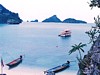
Moo Koh Angthong (หมู่เกาะอ่างทอง)
Thai. ‘Gold Basin Group of Islands’
or ‘Gold Basin Archipelago’. Name of a National
Marine Park in
Surat Thani
province, covering an area of
102 km². Angthong National
Park consist of an archipelago with a total of 42 islands.
On one of them, i.e. Koh Hua Tah Lap (เกาะวัวตาหลับ),
which means the ‘Island of the Cow with Sleepy Eyes’, is a huge cave known as
Tham
Bua Bohk (ถ้ำบัวโบก),
i.e. the ‘Cave of Waving
Lotuses’ or ‘Waving Lotus Cave’ (map
- fig.),
while on Koh Mae Koh (เกาะแม่เกาะ), i.e. the
‘Mother Island of Islands’, the end of a hiking trail to an 240 meter high pinnacle,
with stunning views of the archipelago, has a hidden treasure, i.e. a mountain lake
known in Thai as Thale Nai (ทะเลใน), i.e. ‘Inner Sea’ or the ‘Sea Within’, which
is in English referred to as the Emerald Lake and nicknamed the Blue Lagoon (map
- fig.).
Apart from a ranger station, none of the islands are inhabited by humans and its
wildlife includes
Dusky Leaf Monkeys
(fig.).
The group of islands is located in
the
Gulf of Thailand,
off the coast of Surat Thani province, roughly between the mainland
and the
islands Koh Samui (fig.)
and Koh Pha Ngan (fig.).
It is also referred to by many other designations, such as Koh Angthong, Angthong Marine
Park, Angthong Archipelago, etc. Its name
is also sometimes spelled differently, e.g. as Ko Ang Thong or similar. See
Angthong for the Province and city in central
Thailand.
See MAP.
回


|