|
Nan (น่าน)
Thai. ‘Territory’. A province (map) in North Thailand with a
capital of the same name that has a population of approximately 25,000 and
which
is situated 668 kms
from
Bangkok, as
well as the name
of a river in northern Thailand.
Excavations in the region have revealed that the area around
Nan has been inhabited for many centuries. Stone tools found in the
soil and in caves are estimated to be at least several thousand
years old. The area was first ruled by and under the control of the
phaya
Phu Kha (ภูคา).
In the late 13th century, the first city was established by
chao
khun Fong (ฟอง), the successive
ruler and a blood relative of Phu Kha. This city was named either
Phlua (พลั่ว) or Pua (ปัว),
which later was called Wara
Nakhon (วรนคร)
and was founded as the centre from where the area was administered.
In the 14th century the local ruler moved the city from Pua to the
area of Phu Phiang Chae Haeng, on the East bank of the Nan River.
According to legend, the present city originated in 1357, when phaya
Pha Kong (ผากอง), the local ruler of Nakhon
Damri (นครดำริ) and a son of the then ruler
of Nan, had a visionary dream at the time he wanted to built a new
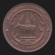
city. In this dream he saw an ox crossing the Nan River and draw a
plan in a certain area consisting of a square structure, thus laying
the fundament for the new city. However, when he woke up he saw this
plan existed for real and he had the new city walls built
accordingly, moving the capital again, to its present location on
the West bank of the Nan River. It was a very rural and remote
independent kingdom with few connections to the other kingdoms of
the region and though its rulers were related to the founders of
Vientiane,
the realm became an ally of the
Sukhothai
Kingdom, as it was easier
accessible from the South. Nan, together with
Phrae and Luang Prabang, are
mentioned on the
Stone of Ramkamhaeng
as some of the places, whose submission Sukhothai had received. In
some inscriptions it is also referred to as Kawnan
(กาวน่าน), Kawthet (กาวเทศ), Kaw (กาว),
Nan (with different Thai spelling, i.e. นันท์) and Nanthaburi (นันทบุรี).
In the 15th century, when the power of Sukhothai declined, and with
the death of phaya Pha Saeng (ผาแสง)
in 1462, the last ruler of the Phu Kha Dynasty, Nan became a
vassal of the Kingdom of
Lan Na. When in 1558 Lan Na was conquered
by the Burmese, the Lan Na ruler in charge of Nan fled to Luang
Prabang and in 1559 also Nan fell to the Burmese and stayed under
Burmese rule until 1785. During this time Nan tried to liberate
itself several times, yet without success. When the Burmese rulers
were finally driven back, Nan in 1788 had to accept the new Siamese
rulers from
Rattanakosin. In 1893, after the
Paknam crisis,
Siam had to give a large part of
eastern Nan to French Indochina. Nan had been able to keep some
degree of independence from the Siamese rulers and it took until
1932 before it became fully integrated into Thailand, becoming a
Thai province. In the early eighties both communist insurgents and
local bandits were active in Nan, but with the help of the Army and
the more stable political system the province improved
significantly. There is also a local legend that relates that Phrae and
Nan were once one kingdom, which was divided among two brothers into two territories (nan)
to enable easier and better rule. Nan's places of interest include Wat Phrathat Chang Kham
Worawihaan (map
-
fig.)
and
Wat Phumin (map
-
fig.). The province has fourteen
amphur and one
king amphur. Pronunciation Naan.
See also
Nan data file. 回


|

