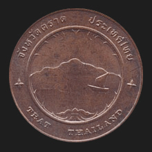
Thai.
Name of a province (map)
and its capital city in East Thailand, 315 kms southeast of
Bangkok. Like
Chanthaburi,
the city of Trat is known for its trade in gemstones, thanks to
the many sapphires and ruby mines. The markets for this gem trade,
known as ‘talaat phloi’, are open daily and attract buyers from
around the world. The province borders
Cambodia, with
Hat Lek at its southernmost point. In front of the coast lies Koh
Chang (map),
a National Marine Park (map
-
fig.) and the second largest (492 kms²) and most
mountainous island in Thailand (fig.), with peaks of up to 744 meters
(fig.). In
these coastal waters a small sea battle took place on 17 January
1941 between the French and Thai Navy killing 37 Thais.
Besides a large monument
(fig.),
this event has been commemorated (fig.)
annually since 1986. The province has two
amphur
and two
king amphur, and is the only
province in the country that borders with only one other Thai
province, i.e. Chanthaburi. It also has the narrowest land-area in
the nation, an part of only 450 meters wide and located on the Trat-Khlong Yai route,
and is home to the tallest person in the country, i.e.
Nang
Ma-li Duangdi. Pronunciation with long vowel, i.e. Trāt, Traat or Traht. See also
Trat data file.
回